Research Highlights > Coupled Regional Climate Models in BALTEX
Coupled Regional Climate Models in BALTEX
A main research goal of BALTEX is the establishment of coupled regional climate models which are able to simulate the environmental processes within the Baltic Sea basin. This is a very ambitious task, and many components must be put together. It can be regarded as a regional contribution to the effort of "Earth System Modelling", which strives to integrate as many natural and anthropogenic processes as possible, which shape the environment of the Earth.
When we talk about coupling in regional climate modeling, we refer to the different compartments in the climate system: the atmosphere, the ocean, sea ice, and the land surface with rivers, lakes and vegetation. Originally, each of these compartments is modelled separately because the processes are either too different, or they act on different spatial or temporal scales. For example, ocean currents are much slower than atmospheric currents, and heat transfer is much faster in the atmosphere than in the ocean.
In reality, however, the processes in all of these compartments interact with each other to form the climate system, and an attempt to simulate the climate system as a whole needs to integrate all interacting processes. BALTEX scientists have successfully coupled different sub-models to arrive at two integrative model systems for the Baltic Sea drainage basin: BALTIMOS of the Max-Planck Institute for Meteorology (Germany) and RCAO of the Swedish Meteorological and Hydrological Institute (SMHI) in Sweden.
BALTIMOS
BALTIMOS stands for "BALTEX Integrated Model System" and integrates the atmosphere, the sea (i.e. the Baltic Sea), and the land surface of the drainage basin. The figure below shows how the different sub-models REMO (Atmosphere), BSIOM (Ocean/Sea Ice) and a vertical soil model are interconnected by atmospheric processes and the runoff model LARSIM.

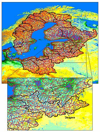
In LARSIM, the entire Baltic Sea catchment basin is mapped as sub-catchments, and a detailed river routing scheme translates the real hydrological topography quite realistically into the numerical model.

RCAO
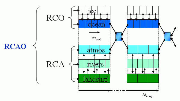
The Rossby Centre of the Swedish Meteorological and Hydrological Institute (SMHI) has developed the model system RCAO which couples the atmosphere and land sub model RCA (which includes a hydrological sub model with river routing) with the ocean/sea ice model RCA.


|

